The High Points of America
 EACH STATE IN THE USA has one point of ground that is higher than any other. These are the high points of the nation. Some are hard to get to, and some have roads and gift shops at their summits. Some are lower in elevation than communication towers and buildings in their state, and some are barely perceptible rises of land in farms or back yards. An overview of these high points provides an interesting typological and supremely topographic portrait of the USA.
Remote High Points
Seventeen state high points require relatively serious hikes of at least a few hours to get there. Of these, twelve could be considered Alpine, or more than 11,000 feet in elevation. The most extreme case of course is Alaska’s Mount Denali, which despite being 20,320 feet tall, has been summited by around 15,000 people, who generally take two weeks to do so. More people have tried than made it all the way to the top, having to turn back due to health or weather. More than 100 have died trying.
The other Alpine high points requiring major hikes are in Western states, and are, in descending order: Mount Whitney, California (14,494 feet); Mount Elbert, Colorado (14,433 feet); Mount Rainier, Washington (14,411 feet); Gannett Peak, Wyoming (13,804 feet); Kings Peak, Utah (13,528 feet); Wheeler Peak, New Mexico (13,161 feet); Boundary Peak, Nevada (13,140 feet); Granite Peak, Montana (12,799 feet); Humphry’s Peak, Arizona (12,633 feet); Borah Peak, Idaho (12,662 feet); and Mount Hood, Oregon (11,239 feet). Because of their remoteness, there are minimal amount of constructions at these locations, though a number, including Mount Whitney, have small huts near or at their summits, or have ski lifts or alpine lodges halfway up their flanks, like the Timberline Lodge at Mount Hood.
The next category are undeveloped high points that still require a bit of a hike to get there, even though they are not really Alpine. These include Guadalupe Peak in Texas (8,749 feet); Harney Peak, South Dakota (7,242 feet); Mount Rogers, Virginia (5,729 feet); Mount Marcy in New York (5,344); and Maine’s Mount Katahdin (5,268 feet, and the northern end of Appalachian Trail). Due to remoteness from roads, these high points do not have a lot of constructions on them, though most of these have some kind of plaque or monument at their summit.
West Texas’ Guadalupe Peak has a stainless steel triangular monument at its top, placed there by American Airlines in the 1950s. Harney Peak, high in the Black Hills, a three-mile hike from a road, has a dramatic old stone fire tower perched on the side of the cliff at the summit. Mount Marcy and Katahdin are both in parks, have good views, and are heavily visited by hikers, so their summits are often crowded.
Virginia’s Mount Rogers is the highest of the state high points east of South Dakota that lacks a road to its summit. The view-less high point is in spruce woods in a state park, four miles away from the public road.
Five more of the high points could be considered undeveloped, as even though they may be low in elevation they are relatively remote, and because they are low in elevation or are close to higher or more scenic peaks in adjacent states, they are not really considered destinations for most people. These include Black Mountain, Kentucky (4,039 feet); Backbone Mountain, Maryland (3,360 feet); Mount Magazine, in Arkansas (2,753 feet); Mount Frissell in Connecticut (while not the highest peak in the state, the slope of Mount Frissell, where it crosses into Massachusetts, is at 2,380 feet, 50 feet higher than Bear Mountain, the tallest summit in the state); and Eagle Mountain, the highest point in Minnesota, a lowly 2,301 foot hill on the upper peninsula, which is a 3.5 mile hike from a public road.
Not all of these semi-remote, low high points are completely unaltered though. Maryland’s Backbone Mountain’s summit is owned by a coal company and has a private logging road through it. Kentucky’s Black Mountain has a private road up it to access a tall radio tower at its summit.
But the rest of the high points in the nation, 28 out of 50, are all developed in some fashion. Some are totally built up for visitors, with parking lots and short ADA compliant paths, and others are on someone’s farm or ranch. All have some sort of marker indicating their status as the highest point in their respective states, whether they are open to the public officially or not.
Developed High Points
The tallest of the 28 drivable high points is Mauna Kea, the highest peak in Hawaii. With an elevation of 13,796 feet, the road to its summit is one of the highest roads in the nation. It is there because the summit is heavily developed with observatories. The highest auto road in the nation, incidentally, goes to the summit of Colorado’s Mount Evans, 14,120 feet, though there is a restricted access road to a lab building on the summit of White Mountain Peak, in California, that is at 14,252 feet, technically the highest road in the USA).
A number of high points on public land have limited access roads to viewing towers or former fire towers. In these cases, of course, the tallest point in the state becomes the tower, not the ground it sits on. These include Mount Davis, Pennsylvania (3,213 feet);Timms Hill, Wisconsin (1,951 feet), located in a county park with an observation tower and a taller radio tower that some people climb; and Spruce Knob in West Virginia (4,863 feet). Some points have a simple trail leading from a nearby road to a clearing in the woods with a sign and survey marker, such as Sassafras Mountain, South Carolina (3,560 feet, though recent grading is said to have lowered the site to 3,533 feet).
Some high points have publically accessible roads directly to their summits, or to parking lots just a few hundred yards away, with a graded walking trail leading to the actual summit site and a monument or viewing tower that dominates the summit substantially (making the monument the highest point), such as at Mount Graylock, Massachusetts (3,491 feet); Mount Mitchell, North Carolina (6,684 feet); Clingman’s Dome, Tennessee (6,643 feet); and New Jersey’s High Point Park (1,803 feet).
Oklahoma’s high point, Black Mesa (4,975 feet) is another one of those highest points that is on a slope of a hill whose summit is on the other side of the state line (in Colorado), so the highest point is on the state line itself. On Nature Conservancy land, it is marked with a ten foot tall stone obelisk that describes distances to other near and far places (Texas, 31 miles due south, Kansas 53 miles ENE, Colorado 4.7 miles due north, New Mexico 1299 feet due west, etc).
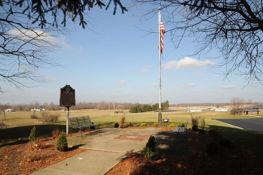
Missouri’s high point, Taum Sauk Mountain (1,772 feet) is in a state park, and has a road to a parking lot with a well-graded ADA-compliant path leading to a bench and overlook with a granite plaque. Campbell Hill (1,550 feet) is Ohio’s highest point. It is dominated by structures remaining from the 1960s, when the Air Force operated a NORAD radar site there as part of the continental early warning defense system. The state took over the site in the 1970s, and it is operated as the Hi Point Career Center, an adult education facility. There is a small patio that overlooks the grassy slope below, with a state historic sign about the high point, and a bench. A weatherproof drawer has a sign in book for visitors.
Alabama’s high point, Cheaha Mountain (2,407 feet) is in a national forest, and has a large stone observation tower built by the CCC, and a lodge-style hotel, restaurant, and store. Brasstown Bald (4,786 feet), Georgia’s high point, is also accessible by paved road, and has a visitor center with a substantial observation tower built on the summit.
The most developed high point in the entire country, though, is one of the most severe. At Mount Washington, New Hampshire (6,288 feet), which held the record for the highest windspeed on the planet until just a few years ago, not only is there a heavily used tourist road to the summit, there has been a cog railway since 1869. Up top is a parking lot, museum, post office, restaurant, gift shop, transmission towers and support buildings, park offices, and the weather observatory. 250,000 people visit the summit every year, and a few meteorologists even live there year round.
Of the low relief high points that are on private land, most have fairly simple monuments constructed by locals, or people who are committed to visiting and marking all the high points of the nation (people known as high-pointers). Many of the Midwestern high points fit into this category. The owners of the farm where Illinois’ high point, Charles Mound (1,235 feet) is located only allow visits on the first weekends of the summer months (the rest of the year high point seekers can take the elevator up one of several buildings in Chicago whose upper stories are hundreds of feet higher in elevation). Hoosier Hill, the high point in Indiana (1,257 feet) is a low wooded rise on privately owned farmland. Hawkeye Point, Iowa (1,670 feet) is next to a very tall farm silo (obviously a higher point), and has a nice monument with directional place/distance sign poles, carved stones, and other features. Mount Avron, Michigan (1,979 feet) has a sign and a bench in the woods along a remote logging road. In the Great Plains, Mount Sunflower, Kansas (4,039 feet) has a couple of nice sunflower sculptures and a plaque. Panorama Point, Nebraska (5,424 feet) has a small stone monument. At White Butte, North Dakota (3,506 feet) there is just a survey marker on a small butte, surrounded by farmlands.
The Lowest of the Highest Points
Despite being one of the lowest high points and located just 200 yards from a public road, Rhode Island’s Jerimoth Hill (812 feet) had been one of the most difficult high points to reach for a long time, as the land owner that controlled access to the property was not friendly to visitors (and was well armed, by some accounts). Eventually, though, concessions were made to allow visits on five days a year, and new owners recently made it available every day from 8am to 4pm. The summit itself is an unadorned exposed granite rock, a couple of feet higher than the surrounding land. It has been owned by Brown University since 1952, and used by its astronomy department, which refers to it as Little Mauna Kea. In December 2011, the state of Rhode Island announced that it was purchasing the site in order to provide public access to it.
Woodall Mountain, Mississippi (806 feet) rises 300 feet above the surrounding plain. A small dirt road leads to the summit, where there is a power line pole. Much of land in the area is owned by a gun club, and visitors are cautioned to take extra care when visiting during hunting season. Driskill Mountain, Louisiana (535 feet), rises about 150 feet above the surrounding plain. It’s summit is reached on a trail that starts behind a church. There is a post with a sign, a small pile of rocks, and a message box at the high point.
The second lowest high point is Delaware’s, and it is so low that it’s not even acknowledged as a hill, but simply as a surveying site known as the Ebright Azimuth (448 feet). A state historic sign along a two-lane highway marks the spot, though the actual site is said to be in a trailer park 50 feet from the sign. The lowest state high point is Britton Hill (345 feet) on the panhandle of Florida, in a small park. There’s a stone monument and a bench. ♦
It should be noted that just about all of the 50 state high points have some kind of weatherproof box at the summit, like a metal ammunition box or a mailbox. Inside is a sign-in list/comment book, usually supplied by a member of the High Pointers Club, a loose network of people who are interested in visiting as many of the USA’s high points as they can. The club’s website, www.highpointers.org, is the authority on the nation’s high points, and, along with www.summitpost.org, and field research by members of the CLUI, is the source of much of the information for this article.