The Great Dismal Swamp
 THE GREAT DISMAL SWAMP, in the southeastern corner of Virginia, is one of the largest remaining forested swamplands in the eastern USA. Its story is a microcosm of American history, to the present day.
At the time of European settlement, the swamp covered more than a million acres, much of the region between Albemarle Sound and Norfolk. Most of the swamp has since been developed into farmlands, and today the part that defied development is a 130,000 acre rectangular remnant at the core of the once vast swamp, and is preserved by state and national agencies.
The Great Dismal Swamp straddles the Virginia and North Carolina state line, with most of it on the Virginia side. This portion is the 110,000 acre Great Dismal Swamp National Wildlife Refuge. The south part is a 15,000 acre North Carolina State Park. Each side has its park headquarters and visitor center, and though managed as a natural area, and teeming with wildlife and scenic beauty, the swamp is a maintained artifact of the natural past.
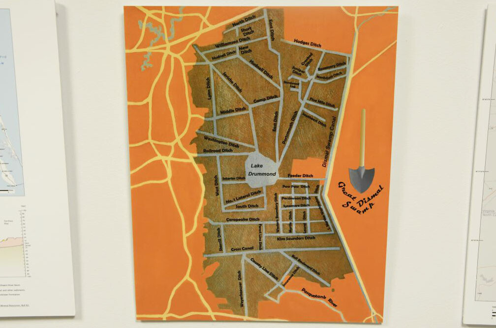
The first European of note to pass through and write famously about it was Colonel William Byrd, part of the survey team that hacked their way through the swamp from east to west in 1728 in order to draw the state line. His desire, like others after him, was to drain the swamp and build a canal though it from north to south. He also is credited for giving the “dismal swamp” its name.
In 1763 George Washington, another Virginian surveyor, who purchased much of what he surveyed, came to the Swamp to implement his improvement plan, draining it for agriculture and building canals.
Washington formed the Dismal Swamp Land Company with other local businessmen, and purchased at least 40,000 acres. He directed the construction of a five mile-long canal known as the Washington Ditch, the first real attempt to reach into the core of the swamp, which is said to be the first of the many American landmarks that now bear his name.
 The swamp remained tenacious, resisting these attempts to drain it, so instead of focusing on agriculture, the company pursued logging. Many old Cyprus trees were extracted and milled into shingles and planks.
Slaves continued to be the labor for the company, and conditions were especially harsh in the nearly inaccessible terrain of the swamp, which was also full of chiggers, ticks, mosquitoes, and poisonous snakes. Since the slaves knew the swamp better than anyone, many escaped into its inner reaches, and even settled there in isolated “maroon colonies.”
Washington also pursued the idea of building a navigation canal along the east side of the swamp, which would connect the resources of the region, like his lumber, to the markets and ports in the north. The canal would connect Albemarle Sound with the Chesapeake Bay, spanning watersheds, and creating a shipping corridor that avoided the long and shallow waters to the south, and the small treacherous cut to the ocean at Okracoke Island.
Construction on the 22 mile long canal started in 1793 by the Dismal Swamp Canal Company, using slave labor, and was completed in 1805, six years after Washington’s death. It was one of the earliest canals made in the USA. As imagined, the canal opened up the region to commerce, and commercial traffic peaked in the mid 1800s. In 1860 the bigger and better Albemarle and Chesapeake Canal opened, and the Great Dismal Canal’s use waned. Then the railroads moved in, and the canal era ended all over the country.

 Today the canal is a relic, the oldest operating artificial waterway in the country, still maintained by the Army Corps of Engineers, including its locks and rotating bridges. It is used primarily by recreational boaters seeking a scenic inland alternative along the Intracoastal Waterway, down the eastern seaboard.
Washington’s share of the land and logging company passed to his heirs, and logging continued into the 1960s. In 1973 and now owned by the Union Camp Corporation, the land was given to the Nature Conservancy, which led to the creation of the Great Dismal Swamp National Wildlife Refuge.
Originally, of course, the swamp formed in a natural balance between water and land. Now, with more than 150 miles of canals in the swamp, the refuge has to try to recreate the original conditions to keep the trees and wildlife intact. It does so through a network of a few dozen control structures along the canals that regulate the amount of water coming in and going out.
In the middle of the swamp is a surreal circular clearing, three miles wide, known as Lake Drummond. Reachable by a dirt road from the west, or by boat along the perfectly straight Feeder Canal that connects to the main canal, the lake is a hole in the middle of the swamp, which itself is a hole in the farmland that surrounds it.
Lake Drummond seems too round and distinct to be a naturally occurring form, and not some byproduct of this altered and artificially maintained swamp, but it is natural, looking very much as it did when it was spied in the 17th century by the colonial governor, William Drummond, who gave it its name. In fact, it is the largest natural lake in the entire state of Virginia, and one of only two. Some speculate that it was formed by a meteorite.
 The lake used to be ringed by hunting cabins, all of which have been removed. Its water appears black due the dark muck just beneath the surface—the lake is only around three feet deep. The water itself is brown in color, like tea, full as it is with tannins and peat. Dismal Swamp water was once prized by sailors and taken in kegs on sea-going journeys. Next to the lake is a clearing, where fires in 2008 and 2011 burned 10,000 acres of forest. Fire and water at the core of the swamp.
The Great Dismal Swamp stands out for what it is, but also for what it is not—the farmland and sprawl that surrounds it. The swamp is in the back yard of Norfolk, the east coast hub for the Navy. A number of training sites and airfields ring the swamp, on land successfully drained for agriculture long ago. Some of them are fading into obsolescence, being reabsorbed. Others are finding new uses, or soldiering on, in these increasingly unstable times. ♦
