Birdfoot: Where America’s River Dissolves into the Sea

THE END OF AMERICA'S GREAT river, the Mississippi, is the subject of a 35-minute long photoscape presentation, on view at the CLUI exhibit space in Los Angeles until May 18, 2008. This exhibit, which is, in a way, about the end of America itself, will be shown later in the year in Plaquemines Parish, Louisiana, all the way downstream.
Contrary to popular belief, the Mississippi River does not stop at New Orleans. Downstream there is another hundred miles of river, flowing between parallel levee walls, until the levees stop and the river splays out into the Gulf, and ends. Not even Mark Twain, the famed chronicler of the river, mentions this part. This is the forgotten, ignoble end of the river that drains nearly two-thirds of the lower 48 states.
If the river is like a digestive tract, carrying away the country's wastes—the effluent of Minneapolis, St. Louis, Memphis, and other cities along it's banks, and the runoff of agricultural and industrial lands from the cornfields of Iowa, to the oilfields of Oklahoma—and everything in between—then the end of the river, the delta of the delta, is like an anatomical orifice at the bottom of the country.
South of New Orleans, as the river makes its last curve to the left past Crescent City, and heads straight southeast to the Gulf, the land on either side is Plaquemines Parish, which had a population of 26,000, before Katrina. Few people come this far down. From the water, initially, there is little to see, just the levee walls rising above both banks, obscuring the landscape beyond. And on the land side too, the river is out of sight, behind the grassy mounds of the levees.
The population of Plaquemines Parish lives in suburbs that, moving south, rapidly evolve into pasturelands within a narrow strip on either side of the river, bound by a front and a back levee. One levee protects the land from the river, and the other protects the land from the sea.

After glancing off Florida, Katrina headed west and bulked up in the Gulf, then turned to make landfall at Buras, in the middle of narrow Plaquemines. The front and back levees, protecting the narrow strip of developed land on either side of the river were easily topped by a 20-foot storm surge. The levees now held the water out, even for days after the storm, until they were breached to drain the debris-choked soup, leaving a residue of the remains of Plaquemines towns: everything from school room desks, police cars, wrecked buildings, and bodies, spilled from crypts, tangled in the trees. Today, rebuilding continues, and now more than half the population has returned.
The road runs behind the levee along both sides of the river. On the east side, the levees stop sooner. The last chance to cross the river is the ferry at Pointe a la Hache, then the paved highway makes a loop where the front and the back levees meet at Bohemia, and heads back north.
On the more populated west side of the river, Highway 23 continues further downstream, passing the restored Woodland Plantation, captured in a Currier and Ives rendition that ended up on the label on Southern Comfort whiskey. South along the river, past Port Sulphur, where the powdered yellow landscape of Freeport McMoran's sulphur plant dissolved into the soup during Katrina; past the Vietnamese shrimp fleet at Empire, whose boats littered the land for months after the storm; past Buras, whose name was emblazed on the town's collapsed water tower making an iconic image of the landfall eye of the storm; past Fort Jackson, a civil war fort that, with its twin Fort St. Philip (now overgrown on the other side of the river), served as a gatepost for the mouth of the river; until finally, on the western bank, the front and back levees meet at the last town, the town furthest down on America's river: Venice.
Over the levee, to the port and marina at Venice, the land becomes level with the sea. Commercial fishing, shrimping, and sportfishing is at least part of why this place exists, as a gateway to the waters of the Gulf. The other, larger reason, is oil and gas. Venice is an industrial port and logistics center for the region's onshore and offshore industries. Drilling mud, equipment, and personnel head continuously to offshore rigs on supply and crew boats. Several helicopter ports, with parking lots full of pickups, serve as a link for crews at the more remote offshore rigs. Venice, last town on the river, is a point of embarkation to the water-bound land and artificial islands beyond the roads.

Past Venice is where the Birdfoot really begins. Beyond the roads, beyond the levees, the Mississippi splays out into the gulf, resembling, from the air, the webbed foot of an aquatic bird. The shape of this landscape is a reflection of the forces at work, a blend of human constructions and terrestrial dumping, a spreading out of one of the most sediment laden rivers in the world—a wet conveyer of earth—slowing to nearly a stop as it enters the sea.
This is a national landscape of disappearance and disintegration. It is a fractal labyrinth of dendritic channels, where land melts into marsh, and marsh melts into water. It is a transformed, massively engineered space, whose dynamics are dominated by the monolithically leveed Mississippi, and cut by thousands of miles of incidental pipeline channels, left ever widening by erosion.
As it disappears, its soft marsh is exposed, and disappears further into the waves. The land is also sinking geologically, the effect of the sediment of America's heartland, washed down the river at rate of a million tons per day, pressing on the continental shelf. Further, the Birdfoot is battered and submerged by hurricane after hurricane. The landscape, this end of America, is breaking up into the ocean.
Within this landscape though people live and work. Oil company workers stay in manufactured industrial housing units bolted heavily to oil platforms rising above the marsh. These workers tend the oil and gas wells and gathering stations, scattered throughout the Birdfoot. The few weekend hunting and fishing communities are being rebuilt. At Trappers Canal, accessible only by boat, where a dozen people once lived, making their living hunting and fishing in the marsh, residents are slowly returning, rebuilding their simple homes, off the grid.
Pilottown is the largest established community in the Birdfoot, though its population is shrinking, following Katrina. Operated as a base for river pilots, people have lived here for nearly 100 years. The main street is a raised walkway, along which a couple of dozen structures once stood, including a school, post office, and grocery store. The population peaked in the 1960s, at around 200 people, before a series of damaging hurricanes destroyed buildings and compelled people to move away. Hurricane Betsy in 1965, was devastating. After Hurricane Camille, in 1969, the school was closed, and remaining students were bussed to school in Venice by boat. In 1996 the postmistress retired, and the post office at Pilottown was closed. The pilots association has been able to keep their zip code, 70081, although it serves a mainly symbolic function now.


Today, some of the largest old buildings are being repaired and torn down, following damage from Katrina. The buildings that remain will support the half dozen or so river pilots that stay here, along with their chef, pilot boat captains, and maintenance crew. The pilots that stay here belong to the Crescent River Pilots Association, which has jurisdiction for the river between Pilottown and New Orleans.
Each foreign flagged ship over 100 tons that passes by this stretch of river is met by a pilot, who is ferried to the ship on a pilot boat, and climbs up the side of the still moving ship on a ladder, to the bridge. The pilot then guides the captain of the ship along the river. When the ships pass River Mile 103, at New Orleans, they enter the jurisdiction of the New Orleans-Baton Rouge Steamship Pilots Association, and the Crescent River Pilots are replaced. Downstream, when ships enter the mouth of the river, they enter the jurisdiction of the Bar Pilots Association, who guide them from the mouth to Pilottown. Heading south from New Orleans, the process is reversed. Each time, the associations levy a fee for their services, around $2,000. With three associations and thousands of ships passing every year, this is clearly a lucrative business for the hundred or so Crescent River Pilots and their peers, and their governor-appointed jobs are highly prized.
Downstream of Pilottown at a point called the Head of Passes, the river splays into three main branches, the "toes" of the Birdfoot. To the east, Pass a l'Outre (Otter's Pass) is the historic and naturally deepest way in to the river, a channel now silted up and shallow in points. It bifurcates before it reaches the gulf, and amid its maze of marsh channels are the lost ruins of Balize, the original "pilot town" near the mouth of the river, a name also once given to a perhaps mythical Carribean pirate hide-out located there, or nearby.
Approaching the river here by ship from London in 1827, after a seven week Atlantic crossing, Fanny Trollope (accompanied by her young son who would grow up to be the writer Anthony Trollope) wrote a descriptive account of the transition from ocean to river, at this older, natural river approach, "The shores of this river are so utterly flat, that no object upon them is perceptible at sea, and we gazed with pleasure on the muddy ocean that met us, for it told us we were arrived." Under the guidance of a river pilot sent from Balize to take them over the bar, she describes the journey further, "I never beheld a scene so utterly desolate as this entrance of the Mississippi. Had Dante seen it, he might have drawn images of another Bolgia from its horrors. Only one object rears itself above the eddying waters; this is the mast of a vessel long since wrecked in attempting to cross the bar, and it still stands, a dismal witness of the destruction that has been, and a boding prophet of that which is to come."
A large camp on the north side of Pass a l'Outre is owned by Don Deladernier, the eldest of an old family that has lived on the Birdfoot for many years. Don is a commercial alligator farmer and duck hunter, and is also the largest private landowner in the marsh, having inherited hundreds of acres of dredge disposal lots that were purchased from the government by his parents in the 1920s. Now in his 80's, he is one of a few people left who have lived their whole, long life in the marsh, in the old way. His remote birdfoot camp, being rebuilt after Katrina, is the legacy of a family whose name, Deladernier, translated from the French, means "of the last."
North of Pass a l'Outre is one of a few government financed island building projects in the Birdfoot, which attempts to counteract the effects of land loss that is occurring throughout the coastal marshes of Louisiana. This one, called the Fort St. Phillip terracing project, involves backhoes equipped with special, wide tracks to operate in the mud, digging and dumping piles of muck to make new land where there was none. A drop in the bucket perhaps, but something at least.
The coast of Louisiana is one of the fastest disappearing landmasses on Earth. Twenty-five to thirty square miles are lost every year. Fifty acres a day, two acres every hour. The reasons for this mass land loss are largely manmade. A major factor is the 10,000 miles of pipelines and navigational canals built by the oil and gas industry that allow erosion deep into the marsh. The Mississippi River levee system also contributes to land loss by restricting the movement of sediment and freshwater to the marshes.
The river carries on average more than a million tons of sediment per day. This sediment, before the levee system was put into place, would flow with the river current, and along with fresh water, spill out into the marshes, building up land. The levees are a continuous wall, extending up to Missouri, that prevent this from happening.

Efforts to protect and rebuild the marshes physically and ecologically, like the Fort St. Phillip terracing project, include the Carnarvon freshwater diversion project in North Plaquemines, which pumps fresh water out of the river into the marsh to help counteract salt water intrusion. The state is also proposing to make a series of cuts in the channels of the Birdfoot (called crevasses) to help sediment return to the marsh.

On the seaward edge of the marsh, natural barrier islands, formed by sediment washed down the river, protect the marsh from perpetual wave and current erosion of the gulf. These islands are disappearing too, leaving the soft marsh exposed. A number of barrier island construction projects, using sediment pumped from the sea floor, are under way.
During hurricane Katrina the coast of Louisiana lost 218 square miles of coastline in 12 hours. 2.7 miles of healthy marsh absorbs one foot of storm surge. As the marshland recedes, the effect of these storms, with their deadly consequences, moves closer to the population centers in Plaquemines Parish and the rest of coastal Louisiana.
At the Head of Passes, where the Birdfoot splits into three, the middle channel is known as South Pass. While Pass A Loutre led to the historic, unengineered channel, used more than 100 years ago, to gain access to the main channel of the Mississippi, South Pass was the first engineered channel into the Mississippi River.
Though South Pass is no longer the main shipping channel, its depth is maintained by Army Corps dredges to a depth of 20 feet. This allows it to be used by oil company crew and supply boats, and large commercial fishing boats. River dredges work these parts of the channel to keep the minimum depth for shipping. The dredges suck wet sediment from the bottom, and pump it through pipelines to dumping sites on shore.
At the end of South Pass is Port Eads, for many years the last settlement on the river. A lighthouse there marks the original modern entrance to the Mississippi. The town is named for the man who established it, and who made modern shipping in the Mississippi River possible, James Eads. Eads became an expert on the fluid and material dynamics of the river through his years of experience as an underwater diver and salvager, based originally out of St. Louis. In the 1870s, Eads conceived of a method for opening up the shallow bar at the mouth of the river. Naturally, as the river slows down at the mouth, the sediment load drops, forming shallow shoals - bars - that prevent larger ships from entering the river. Eads' plan called for a network of jetties projecting perpendicularly from the banks of the river, that forced the flow towards the center of the channel. This, he proposed, would have the effect of speeding up the current, carrying the sediment load beyond the bar, and scouring the river bottom, making it deeper.
No one, especially the government, believed this monumental task would work, so Eads financed it himself, taking on the full risk of failure. Hundreds of workers came to Port Eads to work on the project, and in just a few years after construction was completed, Eads' system had deepened the channel from 9 feet to 30 feet. The Mississippi was now open to ocean-going vessels, and became an economic gateway to the interior of America, and a major economic force in the nation.

A few years later, the government took Eads' system and built it on an adjacent channel, Southwest Pass, and the main shipping channel was transferred there. Port Eads, no longer on the main shipping channel, dwindled into a small recreational fishing marina. Port Eads today is a struggling outpost on the edge of the world, a river settlement that is so close to the river that it very nearly is part of the river. With the exception of the large lighthouse to the south, the settlement consists of a few houses, cabins, and docks, used by sport fishermen, including some of the more affluent members of the Parish government, as a weekend fishing retreat, and as a refuge from the open ocean.
After Katrina, the marina was wrecked. Flipped boats, half sunk barges, and strewn domestic debris are still scattered around. This is a place that is barely there. During Katrina, two of the half dozen or so residents of Port Eads decided not to evacuate, to ride out the storm. Both of them, Wayne Scarabin, age 53, and Roy Clark, age 18, were literally blown away. Their remains have never been found.
The main shipping channel today is through Southwest Pass, the western branch of the three forks that separate at the Head of Passes. Along the pass are several oil and gas processing stations. The largest of these is Burrwood. Historically, Burrwood was a small community of oil workers, river pilots, and fishermen, who traveled up river to Pilottown to socialize and get their mail. It is now a tank farm and oil and gas collection and transfer facility.
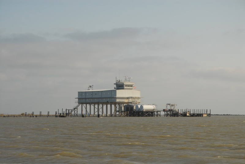
Towards the end of Southwest Pass are two hulks of obsolete lighthouses, and offshore rigs in the Gulf appear above the marsh grass. The land begins to disappear from the river's shores approaching the last building on the river, the Bar Pilots' Southwest Pass station. A handful of pilots stay here to board ships and guide them through the mouth of the river, up to Pilottown.
The edifice, an outpost, furthest out from civilization, is a hybrid structure reflecting its environment, a building resembling a ship, and an oil platform. It is designed to withstand the worst storms imaginable, and survived Katrina intact.
The earthen riverbanks end soon after the Bar Pilots station, and the mouth continues as a structural skeleton for another mile into the Gulf. The jetties, built following the work of James Eads, dissolve into a lattice that ultimately surrenders to the ocean. The land is now gone, broken into a constellation of navigational aids, and oil platforms.
The fresh water enters the gulf as a plume of nutrient rich liquid earth. Nitrates and phosphates from America's heartland fuel algeal growth that sucks up the oxygen dissolved in the water. The resulting lobe of hypoxic sea, known as the "dead zone," can grow to over 5,000 square miles. But that's another story. ♦
VIEW BIRDFOOT: WHERE AMERICA’S RIVER DISSOLVES INTO THE SEA
The exhibit Birdfoot: Where America's River Dissolves into the Sea, is on view at CLUI Los Angeles until May 18, 2008. It was presented using the CLUI's "photoscape" presentation method, a series of photographs and text presented sequentially as a looping digital slideshow, 35 minutes long. The soundscape, a suitably ambient meandering music, was a recording made by Chas Smith, called Endless Mardi Gras, on the Cold Blue label. The presentation was made possible by the support of the Andy Warhol Foundation for the Visual Arts and The California College of the Arts Curatorial Practice Program.