Curious Oranges

THE CLUI DELVED DEEPLY INTO Orange County (the notorious "postsuburban" county south of Los Angeles), for an exhibition commissioned by the Beall Center for Art and Technology at the University of California in Irvine. The exhibit, entitled Curious Orange: Points of View of the Landscape of Orange County, featured twenty sites in Orange County, selected from over 100 sites unearthed during research conducted during the previous year.
The invitation to create this exhibit was of special interest to the CLUI given the nature of the subject, a region that is rarely physically examined in a comprehensive manner, though it is often discussed critically, and the opportunity to work with some new and promising exhibition technologies.
Orange County is sometimes cited as one of the most advanced forms of American landscapes: the state-of-the-art dense, homogeneous, affluent, high-tech, mall-centered, franchise-studded, car-oriented, master-planned community of the future. This, some theorists say, is where many of us are headed if things keep going as they are now. Whether or not this true, Orange County is indeed an advanced and sophisticated landscape with clearly superlative qualities. Nearly 3 million people live in this community defined by a county line that forms a rectangle roughly forty miles long and twenty miles wide, mountains on one side and ocean on the other. The CLUI set out to describe the systems that make this place work (water, waste, transportation, communication, etc.), how it looks, and what it might mean, to its denizens, and to the rest of America.
The final display consisted of four projections, and four trackballs mounted on stands in front of each projection wall. Using the trackball, visitors could choose sites to examine in detail from a projected satellite image of Orange County. Each of the 20 sites, indicated by an orange dot on the satellite image, was depicted through video, shot from a static digital video camera from a fixed location. There was also a text caption for each site.
"The hype about interactive technologies is a bit tiresome," said program manager Matthew Coolidge, "but the truth of the matter is that it is possible now to get closer to the experience of actually seeing a place using a large projection format, and to creating a sense of exploration and spatial organization by using a hyperlinked map or satellite image. This seems to be the logical progression for some of the space displacement-type programming we produce."
CLUI field researchers logged over 3,000 miles in Orange County over the research period, to collect the information, photographs, and video tape, and to conduct site visits and interviews with representatives of these locations. The exhibit was on view from May 5 to June 17, 2001.
Sites portrayed were chosen to represent the structure of Orange County – the infrastructure, and the extrastructure - to provide a cohesive and compelling portrait of Orange County as a place.
Starting with the most apparent and prevalent form of land use in Orange County, the exhibit addressed housing and residential development by representing two extremes of this phenomena. In southern Orange County, where the most space remains for future development, Ladera Ranch is one of the larger master-planned developments currently under construction, and expresses the trend towards denser, neotraditional developments that attempt to build-in a sense of community and common space. In addition to building in this sort of "new urbanist" style, Ladera Ranch is connecting all the houses with a cable intranet that creates a parallel, electronic version of the community, with local discussion groups, community events postings and the like.
On the other end of the housing spectrum is the 60 year-old El Morro Village mobile home park, which is a row of trailers right on the beach, on the otherwise upscale coast near Laguna Beach, and Crystal Cove, a nearby cluster of old Irvine Ranch beach shacks that are still occupied by full-time residents. These two communities represent some of the last vestiges of old Orange County beach life, and both are about to disappear, as the land on which they rest, beneath the encroaching new housing developments, is now a state park.
Nothing creates a sense of community better than a shared disaster. So the exhibit showed sites within the county where officials train and prepare for all sorts of possible, and inevitable calamities. At the North Net Fire Training Center, for example, emergency crews, including fire departments from all over the county, emergency medical technicians, and urban search and rescue teams, train for events such as fires, earthquakes, and associated structural collapse. And at the Emergency Operations Center, a hilltop facility visible from many points in the eastern parts of Orange County, on top of Loma Ridge, officials from the Emergency Management Department keep this county-wide command center ready to take control in the event of an earthquake, terrorist attack, or accident at the San Onofre nuclear power plant (located just outside the county limits). In addition to extensive communication capabilities, the EOC has stores of fuel, food and water, and can serve 140 emergency authorities in self-contained mode for up to two weeks.
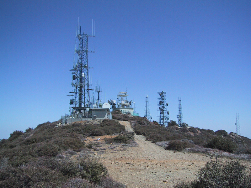
As a society dominated by high-tech industries and high-tech living, communication infrastructure is of special importance in Orange County. This infrastructure was represented in the exhibit by the Santiago Peak Transmitter Site, located at the highest point in Orange County, the 5,687 foot Old Saddleback. The peak is surmounted by a cluster of over 50 antennas and 20 support buildings that take advantage of the broadcast range offered by the high altitude. Also, the earthstation for the largest cable company in Orange County, Cox Communications, was shown in the exhibit. This modest building, with ten large satellite dishes, is the portal through which the signals from broadcast satellites flow, before they are pumped out to about 40% of all cable subscribers in the county.
Many of the distinct nodes in multicentered Orange County are centered around large shopping mall complexes. Fashion Island, in Newport Beach, is a good example of this development practice, as it is one of the early commercial anchors in the master plan of the Irvine Company, the privately-held corporation that owns one-sixth of Orange County, and operates out of its headquarters at 550 Newport Center Drive, overlooking Fashion Island.
The other end of consumption is, of course, excretion, and thus the waste stream of Orange County was represented in the exhibit as well. For dumps, the Prima Deshecha Landfill stood out, as though not currently the busiest of the three active landfills in the county, it has the most growth potential, and covers the largest area, at a dramatic site in south Orange County that even has ocean views.
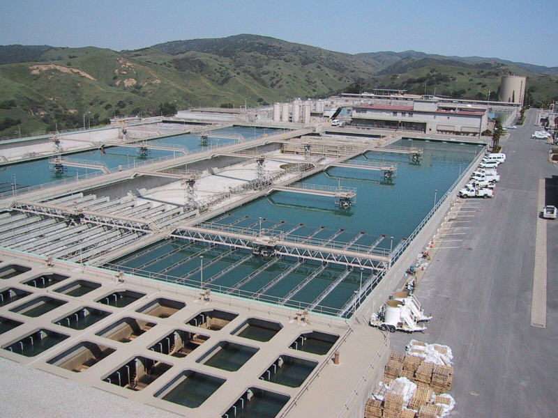
For liquid wastes, two connected sewage plants treat most of the wastewater in Orange County. Plant #2 is larger, and is located on the coast, where the five mile-long offshore outfall pipe seems to not quite be long enough, as Huntington Beach is often closed due to high pollution levels. Water Treatment Plant #1 is in appropriately-named Fountain Valley.
Manifestations of the local economy on the landscape of Orange County were addressed through a number of representative sites, including Disneyland, which with 15,000 workers is the largest employer in Orange County. Aerospace has been at the heart of Orange County’s economy since WWII, and continues to be important today, from Raytheon in Fullerton, to Boeing in Anaheim and Huntington Beach (Boeing is, in fact the second largest private employer in the county). To represent Aerospace in the exhibit, the more obscure and intriguing Capistrano Test Site was selected. This is a remote, 2,700 acre R&D complex in the hills at the edge of Camp Pendleton, operated by TRW's Defense Space Systems Group. It was built up dramatically to support space-based weapons systems in the 1980's, and is still at work on advanced and powerful chemical laser systems, as well as radar and propulsion systems.
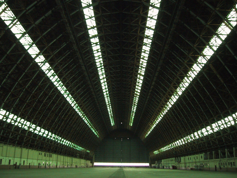
As is so often the case, the current development patterns, and the establishment of the high-tech economy in Orange County, owes much of its existence to the military. Two major military sites created in WWII are in closure limbo right now. The former Tustin Air Station has two massive hangars that were built to house Navy blimps during WWII. At 1,000 feet long, the hangars could hold several blimps each. Their use for this was brief though, as blimps were taken out of active service by 1950. The 1,600 acre base evolved into the largest Marine Corps helicopter base in the country, until it closed in 1999. Among the proposed uses for the hangars now are as soundstages for the film industry. The Hollywood film Pearl Harbor recently filmed in one.
The larger and more controversial of the two closed air bases is El Toro. Until the closure of the base in 1999, El Toro was the largest Marine Corps air installation in the western United States, with fighter jets training over the Pacific, and over ranges in the Imperial Valley and beyond. Even before the departure of the Marines the debate about whether to turn the base into a commercial airport has been perhaps the most talked about land use issue in Orange County. Nearby residents, concerned about traffic and noise, oppose the new airport, while residents who live in the generally affluent communities near John Wayne International, the only major airport in Orange County, are in favor of El Toro’s conversion. In the meantime, the 4,700 acre base, still owned by the Navy but leased to the county, is nearly entirely devoid of activity.
The military is still active elsewhere in Orange County. The Seal Beach Naval Weapons Station is the Navy's primary munitions storage and loading facility on the West Coast. About 100 ships are loaded and unloaded here every year, either at the wharf on the edge of the base, or at sea, with weapons transported by barge and helicopter. The 5,000 acre base was established in 1944, and contains 127 earthen munition storage magazines, all of which are in use. Nearby, the Los Alamitos base is the other active military base in Orange County, and is used by all branches of the armed services for logistics and training.
Other sites featured in the exhibit included the AES Power Plant, the only major power plant in Orange County, which otherwise gets its power from outside the county; the Central Jail Complex, which is the largest of the three correctional facilities in Orange County, and is located in the county seat of Santa Ana, conveniently across from the County Court house; the elaborate water supply engineering project that uses wastewater to recharge the aquifer; the Gypsum Canyon bulk products area, one of two large quarries with cement and asphalt plants, where loose material is extracted and processed, supplying the material for the roads and buildings of the county's new landscape; the southern end of highway 241 near Mission Viejo, which marks the abrupt end of Orange County's toll road network, the only toll road system in the state; and an orange grove that may be the largest remaining orange grove in Orange County, where the trees are harvested by a commercial farming company, which sells the oranges overseas. Orange County, of course, gets its name from the oranges that were grown throughout the region. The largest agricultural crop by far in Orange County today are nursery plants, used for landscaping in the new developments, and decorating the new homes.